These bulletin blogs represent news about Finavon and the South Esk, and my views as a riparian owner. They are not the views of any other organisation, nor are they designed to promote the interests of any individual or organisation other than Finavon Castle Water and factors affecting the fishery. Tony Andrews
The structure of a river catchment is one of the factors that determines the breakdown of the river’s stock of salmon – and maybe sea trout – into distinct populations. The shape of the catchment, altitude, gradient, topographical features (such as waterfalls), geology and chemical characteristics of its water, define a river’s migratory salmonids in terms of run timings and the predisposition of its salmon to return as grilse or multi sea-winter salmon, as well as variations in behaviour of sea trout. In big rivers, like the Tay or Dee, that may seem an obvious statement, but for a little river, such as the South Esk, we may overlook the importance of its smaller tributaries, and the role they play in the evolution of the characteristics of the stock of the whole river catchment.
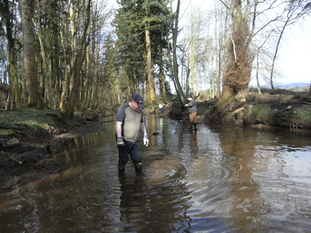
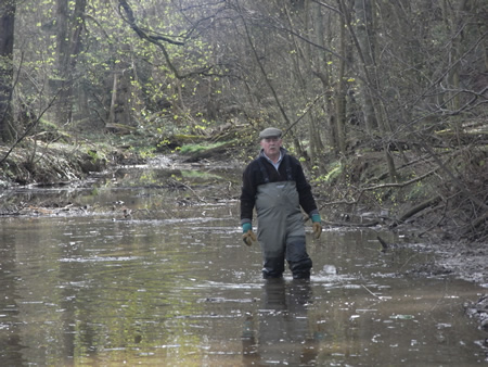
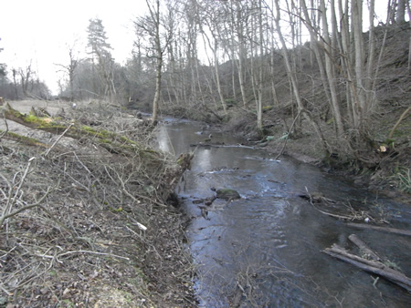
The Lemno Burn just upstream of its confluence with the South Esk at Finavon. The photograph above was taken during a cleaning up operation by volunteers in April 2012, which involved moving tons of rubbish from the burn, whose gravel bed was covered by a thick blanket of gooey silt, up to 2′ 0″deep in places.
The Lemno Burn is a much abused drain for agricultural run-off and chemical enrichment from the intensively farmed Vale of Strathmore. There is anecdotal, but I think reliable, evidence that the Lemno was once an important spawning burn. Farmers upstream of Battledykes, through whose land the King’s Burn flows, tell of dead salmon kelts washed up on the banks of the burn after winter floods. As far as I am aware, there has not been any redd or official juvenile count in the King’s Burn in recent years. My guess is that it still supports a stock of salmon and trout, albeit a diminished one.
The photo above shows how the artificially wide channel and silting up of the burn has slowed the current and reduced scouring, even in a spate. By getting the water moving again we hope to reveal the good quality gravels beneath the silt and encourage fish to use the burn again.
Silt, sewage, pollution and utrification have severely damaged the habitat for spawning and juvenile salmon and sea trout once provided by this South Esk tributary. Despite the degraded condition of the habitat in some parts of the Lemno, electro fishing the middle and upper reaches by Marine Scotland scientists has revealed some very large parr, especially in the area of the confluence with the King’s Burn at Battledykes. There is no record of whether these fish were salmon or trout, or whether there is a mixture of the two. If we can restore the Lemno to a level that can support a diversity of aquatic life, it is likely that the burn will once again make a valuable contribution to the recruitment of salmon and sea trout.
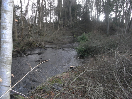
Blocked by trees and accumulated rubbish, and full of the detritus of years of neglect and a thick ‘porridge’ of silt, the Lemno Burn is far from the ideal environment one would look for in an important tributary of the South Esk. But even in the photo above we can see the potential for restoration with the healthy flow and substrate of good quality gravel and cobble. If we can reduce the tree canopy to let the light in, we should have more phyto and zoo life in the burn, which should lead to providing the food necessary for healthy juvenile fish abundance.
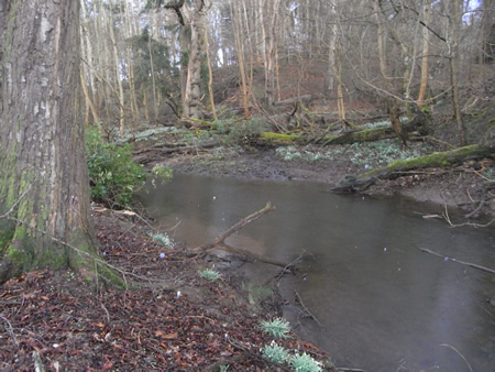
Another photo (above) of the degraded channel of the Lemno Burn in its lower reaches. The accumulation of feet of glutinous silt at this point ensures no salmon or sea trout could spawn in this part of the burn.
If you walk up the Lemno Burn from its confluence with the South Esk at Finavon’s Red Brae Pool, the first thing that strikes you is the unnatural width of the channel downstream of the A90 dual carriageway. The channel is indeed an artificial one, because it was the lade of the roundstone dyke at Tannadice which was removed in 1946. Prior to that time the Lemno Burn joined up with the lade which provided water power for the mill on the Finavon Estate. When the water from the main river was diverted into the lade by a sluice on the south end of the dyke it combined with the water from the Lemno to make a sizeable stream. In low water the effect of the diversion was to discourage fish from running, with the result that they would gather in large shoals in the pools immediately above and below the Red Brae.
The last mile of the Lemno Burn, between the A90 and where the burn joins the South Esk, is a heavily wooded section. Over the years the tree canopy has spread out and removed all direct light from the sun. The photo above shows how the burn now looks after a major tree thinning operation in the winter of 2011/12.
In this summer’s blogs I have commented on the importance of one of these smaller tributaries – the Rottal Burn – and the rather surprising lack of our knowledge about its role in contributing to recruitment of juvenile salmon and sea trout prior to the start of the restoration project. It would I think have been useful to have had a baseline from which we could measure the effects of the project on populations of migratory fish using the burn. The lack of that baseline means that we may have to resort to guessing, which, for those of us who take an interest in the South Esk, is all too familiar a situation!
While the Rottal Burn is an upper catchment tributary and, as such, a natural destination for early running salmon – producing mainly S3 smolts (but maybe some S4s amongst them), the Lemno Burn is a middle catchment tributary. The Lemno Burn’s confluence with the main river at the Red Brae Pool on Milton Beat of Finavon Castle Water is about 15Kms from the tide at Bridge of Dun. The ‘plateau’, which I described in the previous blog, where there is about 500 metres of gentle gradient between two much steeper gradients, seems to be at about the right distance from the tide for migrating fish to rest. Spawning fish arriving at the mouth of the Lemno in the late summer and autumn may have used the burn to gain access to the King’s Burn at Battledykes. One of the radio receivers used in the tracking project is currently sited on the Lemno Burn. It will be interesting to see if any spring salmon use this burn.
The Lemno Burn may be more like the Pow Burn, which is the lowest of the South Esk’s tributaries and provides habitat mainly for sea trout, or like the tributaries of the upper catchment catering for the needs of salmon, or both species. It will be interesting to find out; and the best place to start is to clean up the lower reaches and improve conditions for spawning and juveniles further upstream. Work in progress.
TA 20 September 2012
